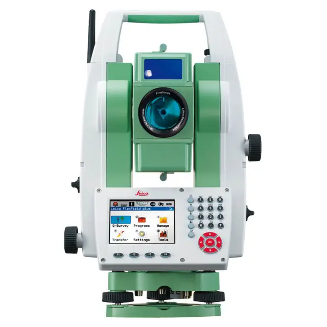
Total station Leica TS-09 Plus R1000 1″
The Leica TS09plus R1000 1″ Arctic one-second frost-resistant electronic total station is designed in full compliance with the highest Swiss Technology quality standards and designed for use in extremely low temperatures.
USD · Volume pricing available
カテゴリー:
Certifications
Global Shipping 7-14 Days
DHL, FedEx, UPS, Air & Sea
Genuine Products
Authorized distribution
Export License Ready
ECCN, CO, CI, PL, EUS docs
24/7 Tech Support
Pre & post sales
Export Compliance
EAR99AI confidence 50% · NLR — No license required. Standard end-use statement recommended.
Buyer Tier Benefits
Tier discounts stack with volume pricing. Automatically applied after your first order.
Order the high-precision frost-resistant total station Leica TS-09 Plus R1000 1″ Arctic for work in the harshest conditions!
Get the benchmark precision of Swiss technology. The Leica TS09plus R1000 1″ Arctic one-second electronic total station is designed for use at extremely low temperatures. The operating temperature threshold extended to -35°C and built-in display heating guarantee stable operation even in severe frost. The combination of the highest angular accuracy (1″) and the powerful PinPoint R1000 rangefinder allows you to perform the most critical geodetic tasks with maximum efficiency.
-
Reference accuracy and range. 1″ angular accuracy and PinPoint R1000 reflectorless rangefinder with a range of up to 1000 meters and a laser beam visible to the naked eye.
-
Frost-resistant arctic version. Special Arctic version with an extended operating temperature range up to -35°C, heating and display backlighting for operation in extreme conditions.
-
Maximum performance. High-speed measurements on a reflector (1.5 mm + 2 ppm) and on any surface (2 mm + 2 ppm) at a speed of less than a second per point.
-
Intelligent software. Intuitive FlexField plus software with color touch screen (QVGA, 320×240), graphical prompts and a large set of application programs (3D Road, Stakeout, Resection, etc.).
-
Complete protection and ease of data transfer. mySecurity theft protection, IP55 housing, built-in 100,000 point memory, USB and Bluetooth ports for wireless communication with field controllers.
How this extreme conditions surveying tool works
The principle of operation of the tacheometer is to simultaneously measure the angles of rotation of the telescope in the horizontal and vertical planes and the distance to the object using a laser rangefinder. PinPoint technology uses a narrow visible laser beam that allows you to accurately target building corners, edges and other hard-to-reach objects without a reflector up to 1000 meters away.
When measuring with a standard prism, the range reaches 3,500 meters (up to 10,000 m in long-range mode).
A high-precision angle system with four-axis compensation automatically corrects instrument tilt errors. Arctic design includes special lubricants, seals and reinforced components, as well as a display heating system that prevents the touch screen from freezing and ensures trouble-free operation in sub-zero temperatures.
Specifications
- Device type: manual tacheometer
- Guide screws: endless
Angular measurements:
- Angular accuracy: 1″
- Display size: 1″
Reflectorless measurements:
- Range without reflector: 1000 m
- Accuracy without reflector: ± (2.0 mm + 2.0 ppm)
- Time without reflector: 3 sec
Reflector measurements:
- Reflector range: 3500 m
- Accuracy per reflector: ± (1.5 mm + 2.0 ppm)
- Time to reflector: 2.4 / 0.8 / <0.15 sec
- Film range: 250 m
Compensator:
- Compensator type: electronic, four-axis, switchable
- Operating range: ± 4′
- Fixation accuracy: 0.5″
- Method: Four-axis compensation
Spotting scope:
- Magnification: 30x
- Field of view angle: 1° 30′
- Reticle illumination: variable (5 levels)
- Minimum focal length: 1.7 m
Photographic capabilities:
- Camera: no
Food:
- Battery: Li-Ion battery
- Charging time: 2.5h
- Working time: 20 h
Data Recording/Communication:
- Ports: RS232, USB, Bluetooth
- WLAN: no
- RS232: yes
- Bluetooth: yes
- USB: yes
- Card reader: no
- Data format: GSI/DXF/LandXML/user-defined ASCII formats
- Internal data format: GSI/DXF/LandXML/ASCII formats
- Internal memory: 100,000 points, 60,000 measurements
General characteristics:
- Operating system: Windows CE 5.0 Core
- Target indicator: yes
- Operating temperature: –20°C to +50°C
- Dust and moisture protection: IP66
- Device dimensions: 173 x 360 x 226 mm
- Weight with battery: 5.1 kg
Display and keyboard:
- Display type: color touch
- Display resolution: QVGA
- Keyboard type: alphanumeric
- Backlight: heated and backlit display and keyboard
- Number of displays: 1
- Second display: GTS38 (optional)
- Second keyboard: alphanumeric
Center:
- Plummet type: laser
- Centering accuracy: 1.5 mm at 1.5 m
- Auto height measurement: no
Field software:
- Software: Leica FlexField
- Standard Features: Station Setup, Survey, Stakeout, Baseline, Base Arc, Baseline
- plane, indirect measurements, COGO, areas and DEM volume, determination of inaccessible point, roads
- 2D, 3D roads, progress
- Application programs (options): surveying, tunnels.